BLOG
Micro-Scale Photogrammetry: UAS for Construction Monitoring
Point 1: Photogrammetry is not a new science. For hundreds of years, photogrammetry has been applied successfully across varied and vast geospatial extents to help users understand and analyze their environments.
Point 2: Unmanned aircraft systems (UAS) allow for the quick and efficient acquisition of aerial imagery—the very building blocks of photogrammetry. A single UAS can acquire hundreds of photographs in a fraction of the time of traditional aerial systems.
Now, a valid conclusion based on the previous two points might look like this: because photogrammetry is well understood and UAS is great at acquiring photographs, combining these applications makes for easy work.
Right? Well, not exactly.
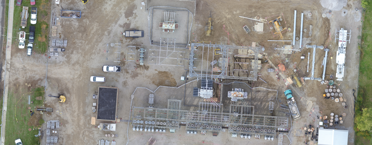
I recently worked on a UAS construction monitoring project. We were focused on a site of approximately 2.5 acres. In the world of traditional imagery, 2.5 acres could fit on a single aerial tile, but in the world of UAS, the site was captured by over 600 images (in a single acquisition).
Now we have what’s called a problem of scale. It’s as if the entire science of photogrammetry is being applied to a tremendous amount of data on a micro-scale that’s equivalent to a suburban cul-de-sac.
Compressing the concepts of county-wide mapping down to a construction site has its challenges. How best do you set control in such a small area? How do you eliminate noise, feathering and seamlines, especially on a particularly “noisy” construction site? How much data is too much or too little? How can I verify accuracy in x, y and z?
As project areas shrink, the necessity of addressing these concerns expands. While a few feet of error may be acceptable across an entire county, small construction sites must adhere to accuracies of inches or less.
Thankfully, though I’m just a cartographer, I am surrounded by surveyors, photogrammetrists, physicists, pilots and other professionals who help me to identify valid solutions. During this construction monitoring project, every one of these unique skill sets was needed in the quest for accurate and repeatable data.
I am happy to report that by merging trusted concepts with new data acquisition technologies and autocorrelation, we are seeing tremendous accuracies in x, y and z. There is no doubt that these accuracies are testament to the established principles of photogrammetry and will ultimately be key to unlocking automation, change detection and object identification.
All my rambling aside, one thing is certain: the application of UAS for construction monitoring is solid. The gut check provided by an accurate, sitewide view of current conditions is worth more than any MS Project file or status report. Determining foundation alignment, pre-fab component placement, on-the-fly rework and correct orientation from accurate, timely data is useful for any large construction project. Furthermore, this gut check cannot be faked and is unlikely to be misunderstood, since an image presents a snapshot of actual condition and status.
Construction is expensive, and accurate data helps control that cost. And while clients may want to attribute these cost and time savings purely to UAS, in fact, it’s truly the approach and the application of solid photogrammetric principles that enable intelligent decision-making and monitoring.

Dan Michalec, PMP, GISP
Dan Michalec is a GIS and project management professional with over 17 years of experience in the industry as an analyst, designer, manager and teacher. More posts from Dan’s unique perspective are on the horizon.