BLOG
—
Geospatial Technologies Enable Renewables to Change the Energy Landscape
The world is changing daily. Forty years ago, people barely knew what a computer was. Twenty years ago, you couldn’t buy a plane ticket, book an Uber or rent an Airbnb on your phone. The past 10 years have brought us countless other life-changing innovations, like drones and self-driving cars. Albert Einstein once said, “The world as we have created it is a process of our thinking. It cannot change without our thinking.” That being said, technology’s disruptive nature continues to transform our world, and that influence has never been more apparent in the energy industry.
Renewables have changed the way the industry plans and distributes energy, and they will soon change the way it stores energy. There has been renewed attention on climate change, but the efforts to find a solution through technology are not new. Many are currently looking to technology to lead us toward a carbon-neutral world. In the past two decades, renewable start-ups have expanded their focus beyond clean energy to energy independence.
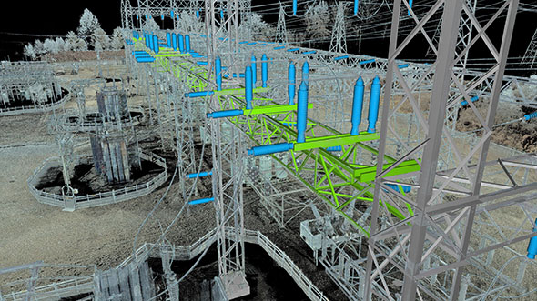
At the center of this energy independence is the ability to utilize geospatial technologies. Just as they have been used with non-renewable energy resources in the past, geospatial technologies will play a significant role in supporting the development and expansion of wind, solar and hydro energy. The most obvious applications of these technologies involve generation siting, facilities management, and economic analysis and forecasting.

Woolpert integrates renewable energy sources into its AEG projects. This wind turbine was installed as part of the firm's 2018 Shor Park renovation in Milford, Ohio
Wind
The most straight-forward geospatial application in the energy industry is the siting of generation assets. For example, when you site wind turbines, they need to be located in places with consistent wind resource availability and variability. This includes understanding the amount of air (volume), speed of air (velocity) and mass of air (density). Through geospatial technologies, we can locate wind turbines in highly desirable sites using the best topographic information available.
Solar
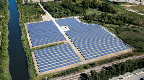
In solar applications, generation siting is also extremely important. The placement and orientation of solar panels is as consequential as the type of solar panel used. A solar panel will harness the most power when the solar radiance hit its surface perpendicularly. Geospatial technologies ensure that solar panels face the correct direction and have the appropriate tilt, which helps ensure that they are exposed to the highest intensity of sunlight for the greatest period of time to produce the maximum amount of energy.
Hydro
One of the oldest renewable energy resources still plays a key role in our energy portfolio. Hydroelectric power is classified as a renewable energy resource because water vaporizes into clouds and recycles back to the surface of the earth as precipitation. The water cycle is continually revitalized and can be repeatedly utilized to generate electricity. Hydroelectric power simply means the generation of power from falling or streaming water. To produce power, dams are constructed on rivers. The constant flow of water is then used to move the turbines. The rotating turbines use the kinetic energy of moving water, which in turn causes the magnets inside the generator to rotate and generate electricity. The water then exits the turbine and is returned to the stream below the dam. Geospatial technologies are needed to monitor water levels, impacts to wetlands, and up- and downstream capacity levels.
Woolpert has been promoting renewable energy sources for many years. This photovoltaic solar array project was completed at Ohio's Camp Perry in 2008.
Geospatial Technologies Beyond Site Location
Although generation siting will fuel the production of large amounts of renewable energy, it represents a small portion of the impact that geospatial technologies will have on the industry. Geospatial tools can model renewable energy production and storage variables, enabling the rates and amounts of energy to be calculated, integrated and managed for both non-renewable and renewable energy sources. In addition to the siting of wind towers and solar arrays, these technologies support the service equipment and the location of networked infrastructure itself.
New infrastructure investments also rely on geospatial technologies to plan, construct and monitor new developments. Renewable energies derive power from natural resources, and GIS coupled with GPS is uniquely positioned to analyze and monitor these processes to make certain that renewable power generation sites are optimally sited and that the power generated is delivered efficiently.
When sustainability is linked to energy flows, we should expect managers of buildings and other large structures and even cities to monitor continuous flows. With the rise of battery storage, each community, business and home will be able to produce energy and contribute to the collective. Monitoring and managing energy production and use locally and across networks will require geospatial tools and technologies to understand how all these systems work, interconnect and operate across multi-modal networks.
Maximizing Energy Production
As geospatial technologies continue to advance, their role in the renewable energy world will expand as well. They will become integral to harnessing maximum energy creation at the lowest cost to deliver the widest and the most effective sustainable impact. Economic analysis and forecasting will support deeper integration and understanding of energy development, distribution and use. Geospatial technologies will work in 3D applications, be linked to financial and economic tools, and provide automated management systems for critical infrastructure.
Renewable energy options are abundant, but their performance and usage are dependent on location. The natural integration of geospatial technologies and renewable energy improves physical resources, facilities, operations, utilization and economics. Geospatial analyses ensure the best fit for every community and improve the decision-making process for all involved. Only through geospatial technologies will we be able to understand, manage and advance renewable energy for the future—which looks increasingly bright.

Ryan Thomas
Ryan Thomas, AABE, AIChE, AMA, is a program director at Woolpert who provides professional consulting services to assist government and private entities with accomplishing their energy sector needs. His experience in multiple industry platforms includes helping clients develop and implement new energy generation projects such as wind, solar, battery and hydrogen storage.