BLOG
—
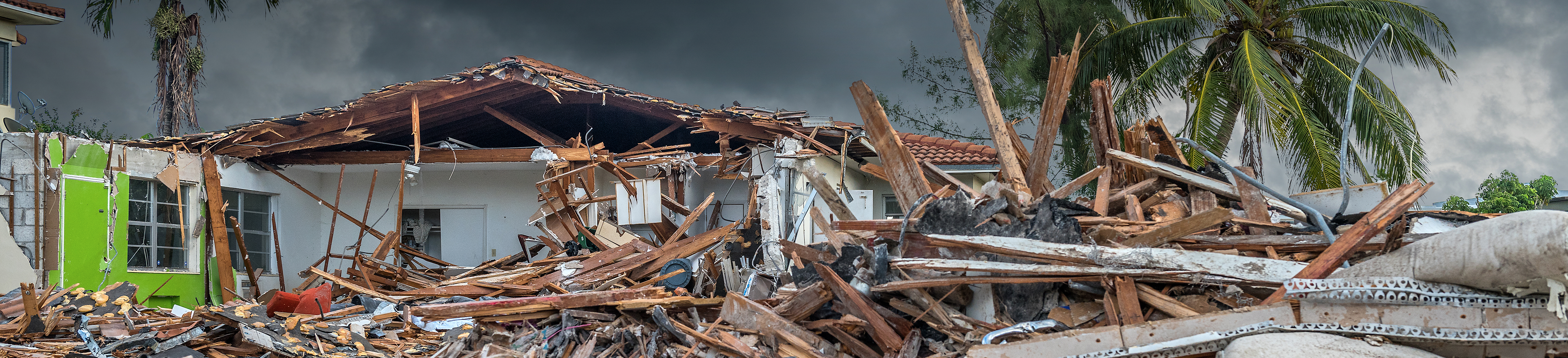
In the Eye of the Storm: Hurricane-resistant Design
In this two-part blog, Nadja Turek and Doug Brown shed some light on designing structures to withstand devastating hurricane damage.
Part 1: Assessing the Risk
As the weather grows seemingly more unpredictable and intense, more and more facility owners are justifying the cost of hurricane-resistant structures. As we head into the 2019 hurricane season, there is no better time to consider ways for preparing our buildings (not just our people) for the next big storm.
According to the National Oceanic and Atmospheric Administration (NOAA), the 2018 hurricane season produced an above-average 15 named storms and eight hurricanes, responsible for approximately $50.2 billion in damages. In addition to hurricanes, last year was a record year for high-tide or “nuisance” flooding on our coasts, and NOAA says 2019 will see even more such flooding.[1] Some reports predict that sustained wind speed could rise to 190 mph in the U.S., leading researchers to speak of the future need for a category 6 storm—which doesn’t currently exist (the scale stops at 5 for any storm sustaining over 157 mph winds[2]).
How does a designer even begin to create a hurricane-resistant structure? It all starts with hazard assessment, a crucial step in light of changing and often-volatile weather. While you may know intuitively that you’re in a hurricane zone, do you also know what is predicted regarding future sea levels, storm surges and winds in your location? Here are a few excellent ways for designers to obtain the needed information:
Review the hazard mitigation plan for the local government agency.
A simple web search will typically locate the desired information. The Federal Emergency Management Agency (FEMA) requires government emergency managers to maintain current hazard plans to receive disaster funding. These plans always begin with a characterization of local hazards and often include probabilities and severities.
Consult future climate models.
This critically important effort helps you design for the future climate, not the past. For example, what is the range for storm surge in the future? [3] If your local plans do not account for consensus-based climate change scenarios, there are still many other resources available. NOAA offers a sea level rise viewer for coastal locations, and the Environmental Protection Agency offers a Climate Scenarios Projection Map. I regularly use and cite reports by the U.S. Global Change Research Program (sanctioned by the DoD, a participating agency) for future regional climate and condition ranges. I also check NOAA’s Regional Integrated Science Assessments teams’ websites for quality reports and predictions on future climates. Down-scaled from global climate change models to specific regions of the country, these resources provide an excellent accounting of regional topography and microclimates.
Become comfortable with ranges, and don’t rely on individual numbers.
Since models vary by emissions scenario and the future is always uncertain, you’ll have to work with a range of possible conditions: temperature, sea level, flooding frequency, storm surge and more. Once you’ve established the range, engage the client to determine acceptable risk and the specific assumptions to include in the project requirements.
Last but not least, you must be prepared to answer the ultimate question: “What does it cost to provide a higher level of protection?”
Stay tuned for Doug Brown’s follow-up blog, in which he provides specific hurricane-resistant design considerations.
[1] Last Year Was a Record-Breaking Year for High-Tide Flooding. 2019 Probably Will Be, Too., July 10, 2019
[2] Category 6? Climate change may cause more hurricanes to rapidly intensify. Sept 11, 2018
[3] The Coastal Assessment Regional Scenario Working Group created a database with regionalized sea level scenarios for three future time horizons (2035, 2065, and 2100) for 1,774 DoD sites worldwide. The database also contains extreme water levels statistics (storm surge without waves and wave run up) for four types of annual chance events (1, 2, 5 and 20 percent) based on historical tide gauge data. This information could be used to establish base flood elevation and potential future flood inundation areas of concern for installations in coastal and tidal areas, if you have a government client who is willing to find it. Frustratingly, the report regarding the methodology is public, but the database is not. The report is called “Regional Sea Level Scenarios For Coastal Risk Management: Managing the Uncertainty of Future Sea Level Change and Extreme Water Levels for Department of Defense Coastal Sites Worldwide.” April 2016