BLOG
The Eyeball Perspective
Written by: Dan Michalec
Cartography offers an opportunity to view our world from a variety of unique perspectives.
For thousands of years, cartographers have tried to create flat representations of our round planet by partitioning, measuring, mosaicking and controlling its surface. Modern cartography has further unlocked entire industries of analysis and intelligent decision-making about the land and our impact on it.
Cartographers like me have the distinct advantage of perspective over the average person. Personally, I have spent countless hours—likely even years—viewing the world from a nadir (or slightly off-nadir) perspective some 4,000 feet above ground level. Most non-cartographer humans view their world from an upright position that is just 5 feet above ground level. They see things from an eyeball perspective.
In countless situations, my nadir-view perspective has made it easy to see things obscured from others. Yet, slightly tilt that nadir view into the third dimension, and like magic, the situation often becomes immediately clear to non-cartographers.
In a brief rotational instant, the flat plane of earth moves closer to the common eyeball perspective.
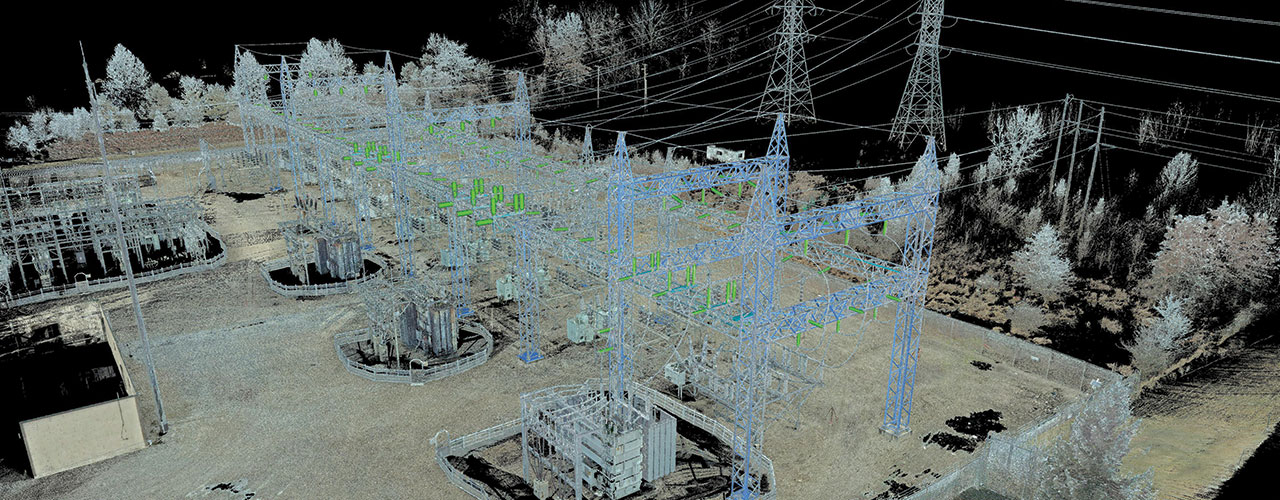
Enter the third dimension and the technology of terrestrial lidar scanning.
While terrestrial lidar is not new technology, recent advancements in hardware, sensors, approach, processing and visualization have transformed the way we use it to analyze the earth’s surface and built structures. Because terrestrial scanners typically operate at eye level to capture dense, highly accurate geospatial data, they help us to rebuild the eyeball perspective for more intuitive analysis and decision-making.
Couple that eyeball perspective with a massive amount of detailed data (photography, lidar, thermal imaging and more), and the possibility for analysis greatly increases—as does its relevance. Of course, collecting survey control to ensure accuracy is a must; the inclusion of survey control bridges the gap between legacy 2D datasets and newer 3D perspectives.
Never before have clients been so close to obtaining absolutely accurate, real-world representations of the environment and their operations within it.
In recent months, my team completed several 3D data acquisition/analysis projects that continually reminded me of the value of the 3D eyeball perspective. A standing view of assets enables end users to remotely “see” infrastructure, understand conflict and change, plan in multiple dimensions, minimize field efforts and make safe, intelligent decisions.
While this technology is transformative, it is not without practical concerns, something my colleague Qassim Abdullah discussed in his blog about UAS. Without the proper understanding of approach and application, results may be less than satisfactory.
Ponder this: after focusing on flattening the earth to a 2D plane for thousands of years, we now find ourselves rebuilding that same environment through a standing, 3D eyeball perspective.
More to follow…

Dan Michalec
Dan Michalec is a GIS and project management professional with over 17 years of experience in the industry as an analyst, designer, manager and teacher. More posts from Dan’s unique perspective are on the horizon.