BLOG
—
Floodplain Mapping, an Age-Old Practice Updated for Today's Flooding Events
Rivers and their floodplains change over time, requiring regular floodplain mapping. Nevertheless, comprehensive floodplain mapping projects are no small undertaking—the United States alone has over 3.5 million miles of rivers and streams.
Surveyors have attempted to map the waterways and floodplains of U.S. rivers for hundreds of years. Despite the advent of advanced geospatial technologies, like lidar and photogrammetry, many floodplain maps remain outdated. Today, failure to map a floodplain in an accurate and timely manner can have serious consequences.
Consider that many communities knowingly or unknowingly live within the boundaries of historic floodplains. People and their property are at risk whenever an unexpected flooding event occurs, especially during a 100-year flood, underscoring the need for consistent floodplain mapping.
Floodplain Maps in Action: Notable Examples of What They Support
Up-to-date floodplain mapping databases support a range of public and private projects, from architecture and engineering to agriculture and storm preparation.
- Flood risk mitigation: Floodplain mapping increases residents’ safety by enabling communities to model and simulate flooding events based on elevation, rainfall, and other historical data. With these models and maps, decision-makers can minimize flood damage by designating safe building areas, restricting development in high-risk zones, and employing other flood mitigation planning strategies.
- Design and construction: Floodplain mapping is valuable for design and construction firms working in areas with seasonal flooding. Whether building a rock jetty or developing a bridge across a strait, floodplain mapping helps architects place, design, and construct infrastructure to withstand potential floodwaters. In terms of scheduling, it can also inform teams of the most optimal times of the year to undertake their projects.
- Agriculture: Floodplain mapping enables farmers to reduce costly water usage, mitigate crop damage, perform land use planning, and identify dangerous geohazards—ultimately boosting farm efficiency and safety. Moreover, it can reveal lowlands on agricultural properties suitable for seasonal flooding, creating opportunities for landowners to lease their property for activities such as duck hunting.
The Importance of Accurate, Up-to-Date Floodplain Data
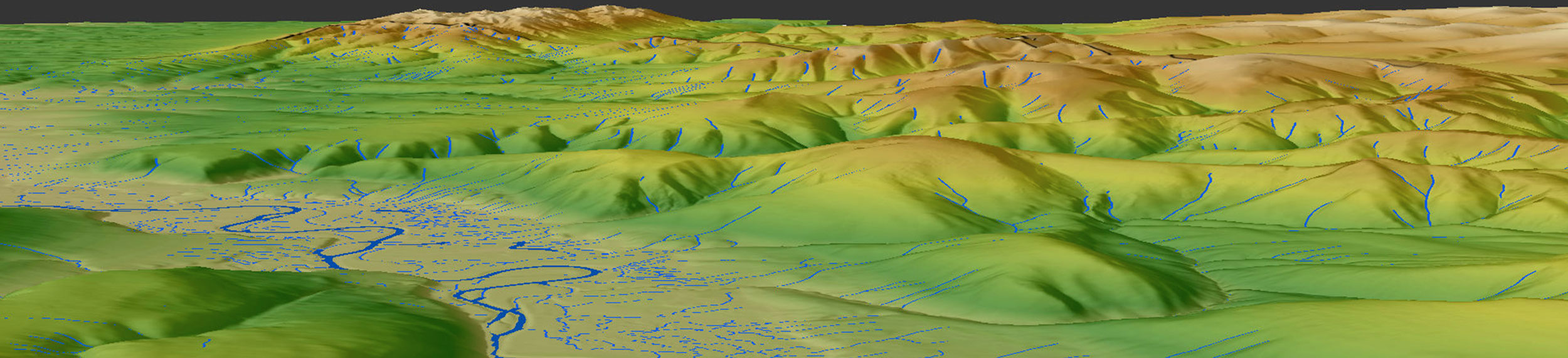
Agencies like the National Oceanic and Atmospheric Administration and the U.S. Geological Survey (USGS) provide datasets that are foundational for floodplain mapping. These organizations and their partners use geospatial technologies and techniques, such as aerial lidar and photogrammetry, to feed geographic information systems, as well as hydrologic and hydraulic models.
These models are only as accurate as the data they rely on. Rivers and floodplains are constantly changing, especially in the wake of natural disasters like hurricanes. Consequently, many key hydrological and topographical databases are outdated. Thankfully, agencies like the USGS are working with strategic partners to update this vital information.
Recently, the USGS selected Woolpert to collect new data across Arkansas through aerial lidar to refresh the 3D Elevation Program (3DEP) baseline. The elevation data obtained by Woolpert will help farmers manage rice field flooding and identify wooded lowlands that could be converted into green tree reservoirs. This data will likewise enhance stormwater flow modeling, optimizing the planning of construction projects.
Some databases, like the 3DEP, can be updated. Others, however, are long overdue for a replacement, as is the case with the USGS’s century-old National Hydrography Dataset (NHD). Presently, Woolpert is collaborating with the USGS on the 3D Hydrography Program (3DHP), which will replace the outdated NHD with a more accurate, lidar-based hydro layer across the continental U.S. The 3DHP will support applications in floodplain estimation, infrastructure planning, and water volume modeling.
What Must Those Living or Working in Floodplains Do?
Any community, business, government agency, or other entity located in or near a historic floodplain must leverage floodplain mapping data—whether preparing for future floods, managing farmland, or undertaking a new construction project. It’s also essential to verify that this data is up to date.
They should likewise consider utilizing machine learning-based flood prediction models alongside floodplain mapping databases. These advanced models can provide near real-time data, making them highly effective tools for flood mitigation efforts.

David Neff
David Neff is an ACSM-certified maritime market director at Woolpert. He has managed hydrographic projects across the United States and internationally, with extensive experience in project management, vessel mobilization, survey planning, data collection and processing, report writing, business development, and product generation.

Brian Stevens
Brian Stevens is a certified photogrammetrist (national) and surveyor photogrammetrist (state of Virginia), serving as a program director at Woolpert. With more than 25 years of experience in the geospatial industry, he has led the Ohio Statewide Imagery Program since 2006, providing aerial lidar mapping of more than 41,000 square miles across the state.
Share this Post