BLOG
—
Woolpert Cloud Solutions: Open for Business!
In my previous post, I provided a short history of Woolpert’s journey from industry-leading architecture, engineering and geospatial (AEG) consulting firm to geospatial cloud services leader. The needs of our AEG clients initially led us toward online hosting for massive data sets, forward-thinking web applications, and creative, customer-specific solutions and integrations in the cloud. During the last five years, we greatly extended our customer business around the Google Maps Platform, and at the beginning of 2019, we made a strategic corporate investment to grow a broader Woolpert Cloud Solutions business unit.
This movement is our response to customer demands and future opportunities. Yet existing and prospective customers continue to ask how the Woolpert Cloud Solutions team can bring unique value to their engagements. It’s a fair question, given Woolpert’s background as an AEG company. In contrast, the majority of Woolpert’s Google Maps Platform customers do not classify themselves as AEG organizations and often have very different business needs.
To meet the needs of our varied customers, Woolpert is actively growing our commercial business through our nationally recognized Google Maps Partner of the Year team. At the same time, we are investing in the following areas:
Geospatial and asset management: We are amplifying our core Woolpert geospatial and asset management expertise by adding cloud-focused products and services. For a company that collects lidar data with its own aircraft fleet and advises clients on effective, cloud-based enterprise asset management, this effort is an obvious fit.
Energy, utilities and government: We are reflecting Woolpert’s strength in energy, utilities and all levels of government. In these markets, we see a huge potential for improved efficiency and cost savings surrounding workforce management and the processing, analysis and consumption of geospatial data.
Cloud Strategy
So, how exactly does Woolpert hope to achieve this? We are focusing on combining clear product strategy, managed services and specialized, third-party integrations. Our Cloud Solutions model has four pillars that speak directly to customer needs.
I’ll dig into each in more detail with future posts, but in the meantime, here is a short summary.
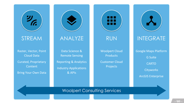
STREAM: Don’t download data—STREAM it! View data (yours and ours) with this geospatial raster and point cloud streaming platform for any API, Web map or GIS/CAD tool.
ANALYZE: Derive valuable insights from Woolpert’s or your own geospatial data in the STREAM platform. ANALYZE is powered by remote sensing and other algorithms created and refined by Woolpert data scientists.
RUN: Run your business with fully managed geospatial and asset management services and end-user applications, all backed by a service level agreement and Woolpert’s site reliability engineers.
INTEGRATE: Integrate third-party products with cloud-based solutions tailored to your specific business goals. Rely on our proven expertise integrating Google Maps Platform, Esri ArcGIS Enterprise, G Suite, CARTO and more.
Open for Business!
Woolpert’s history of helping customers address real business needs is over a century in the making. We look forward to helping you on your own cloud journey, whether it’s guiding you through your first steps or providing the platform for you to take giant leaps.