Aerial Survey to Land New Australian Gateway
 
Image

Background

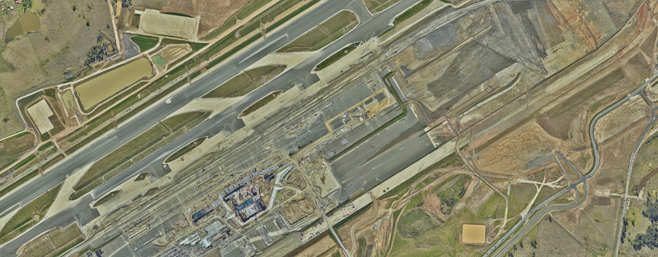
Set to open in late 2026, the Western Sydney International (Nancy-Bird Walton) Airport (WSI) will accommodate up to 10 million passengers each year, and grow to eventually become Sydney’s primary gateway for international, domestic and cargo services.

The CPB Contractors ACCIONA Joint Venture (JV), leading construction for the Australian Government, is delivering four essential packages of work. Woolpert was engaged for its expertise in aerial survey work, and ability to conduct fixed date capture for two of these packages – the Bulk Earthworks and Airside Civil projects. 

Challenge

The Bulk Earthworks and Airside Civil projects involved an area of approximately 1,770ha, with a project schedule exceeding one million cubic metres of material to be placed and compacted across multiple sites per month. Reliable and repeatable progress monitoring of these works required both temporally and spatially accurate data to validate monthly earthwork volumes, as well as facilitate ongoing planning and operational management of plant movements. Some key considerations which lead to Woolpert being engaged include:

  1. Continuous transformation: The working surface was everchanging with excavation, movement and placement of material, with up to 250 operating plant on-site each day.
  2. Time: Drone-based photogrammetry and processing would expend up to a week of resources of the JV survey team each month.
  3. Safety: Land survey methods, including mounted scanners were high risk when working in and around heavy machinery.
  4. Vertical accuracy: Due to the high volume of material moved over the large area, vertical accuracy was significant in accurately substantiating costs.

Solution

Supporting the delivery of the Bulk Earthworks and Airside Civil projects, was Woolpert’s bespoke fixed date capture aerial survey program. 

  • Fixed capture dates enabled by Woolpert’s sizeable aerial fleet: Woolpert delivered monthly high-density airborne LiDAR at 8ppm with a vertical accuracy of 0.05m RMS (1 Sigma) and 10 cm GSD imagery capture for each epoch.
  • Increased productivity through swift data delivery: Woolpert processed large datasets with quick turnarounds, within less than 36 hours from each completion of capture.

Results

Supporting the delivery of the Bulk Earthworks and Airside Civil projects, was Woolpert’s bespoke fixed date capture aerial survey program. 

  • Fixed capture dates enabled by Woolpert’s sizeable aerial fleet: Woolpert delivered monthly high-density airborne LiDAR at 8ppm with a vertical accuracy of 0.05m RMS (1 Sigma) and 10 cm GSD imagery capture for each epoch.
  • Increased productivity through swift data delivery: Woolpert processed large datasets with quick turnarounds, within less than 36 hours from each completion of capture.

For more information, please contact us, and we’ll get back to you shortly.

Client 
CPB Contractors ACCIONA Joint Venture

Location
Sydney, New South Wales, Australia

Purpose
Support ongoing planning and operational management of airport earthworks

Services
Benefits
  • Risks associated with working around heavy haul machinery were negated by using aerial sensors to collect high density LiDAR and imagery over the expansive area of interest.
  • Time and cost related to land survey methodologies available to the JV were reduced through Woolpert’s industry leading aerial survey program.
  • Increased productivity through quick turnarounds on large datasets, enabled the JV to significantly streamline haul routes, resulting in increased earth movement.

Additional Resources 
Transport and logistics