BLOG
—
How GIS Fuels Safety, Effective Asset Management for Utility Companies
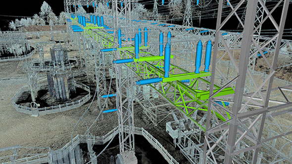
Every utility company should know the location and condition of its infrastructure but unfortunately, that is not always the case. GIS technology is ready and able to address that need, providing easily accessible spatial intelligence to effectively manage utility assets and protect the communities they serve.
GIS technology has been around for about 40 years, helping companies across multiple industries manage their infrastructure and make informed decisions. It has evolved from a basic repository of big-picture datasets and attributes to become a more comprehensive, versatile and precise tool, which can be customized to serve the needs of each company. In the utility industry right now, many companies are undergoing a changing of the guard in leadership as more people who grew up utilizing location intelligence are taking the reins. These new managers have experience with the value of this technology and are therefore more apt to embrace GIS and expand its positive impact within the industry.
Over the years, GIS has become increasingly accessible and more easily integrated into daily utility workflows. Smartphones, tablets and other mobile devices support the use of GIS data in the field, and evolving software provides an abbreviated learning curve to assist veteran engineers, technicians and other crew members who may be resistant to new technology. By applying change management principles, even field personnel, office administrators, managers and others who are accustomed to paper records and familiar-but-outdated software programs can see how GIS will make their jobs easier and enable them to capture, analyze and utilize data they couldn’t before. This new data is especially crucial as it pertains to safety.
For utility companies, safety is and always will be paramount. GIS not only provides updated data regarding the condition of all assets to help mitigate their risk and likelihood of failure, but being able to identify everything from exactly where lines have ruptured to where to shut off power—and to have that information immediately—is essential in an emergency response situation. This information can be used to allocate people and resources efficiently to control damage and recover as quickly as possible.
As the technology and applications of spatial intelligence continue to evolve, benefits are being increasingly realized around the world. For utility companies, the adoption of GIS is invaluable to effectively manage infrastructure, promote safety and protect these valuable assets for the good of all concerned.