BLOG
—
Manned vs. Unmanned Aircraft: Which is Best for Aerial Data Acquisition?
As the capabilities of geospatial data acquisition using small unmanned aircraft system (sUAS or UAS) technologies advance, geospatial data users must consider whether manned or unmanned aircraft is the better choice for aerial data acquisition. To help answer this question, users should consider the scope and needs of each project, including:
- Project size
- Project location
- Time constraints
- Budget
- Anticipated product quality
- Site security and accessibility
- Product type, i.e. lidar versus imagery
This paper compares the strengths and weaknesses of manned and unmanned acquisition technologies for projects of varying types and sizes.
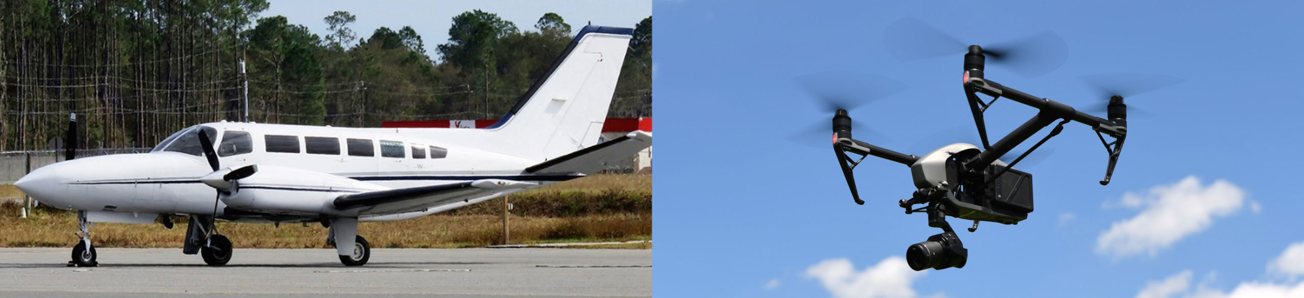
Manned Aircraft Data Acquisition
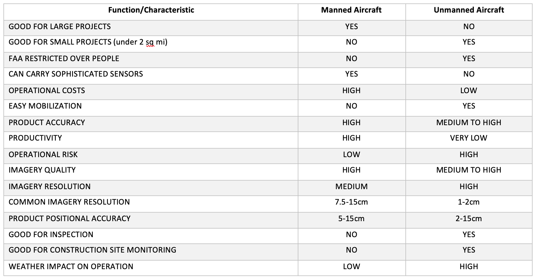
Manned aircraft is a versatile option for data acquisition as many types and sizes of aircraft can be used. Small and low-budget projects can benefit from the comparatively low operational costs of small aircraft, such as Cessna 172 and Cessna 180, while larger aircraft like Cessna 404 or King Air can be used for large projects, such as countywide or statewide acquisitions.
Strength of Manned Aircraft Acquisitions
- Suitability for Large and Small Projects: Project size and budget should dictate the size of the aircraft used for data acquisition. Smaller projects like corridor mapping can benefit from smaller aircraft with lower operation costs. Larger aircraft can be brought in for projects that require endurance and a sophisticated, heavy payload, like lidar sensors and metric digital cameras.
- Capability of Carrying High-End Mapping Sensors: Manned aircraft are suitable for carrying multiple sensors. The more sophisticated sensors necessary for accurate, high-resolution mapping products, like lidar sensors and metric digital cameras, are too heavy for unmanned systems.
- Airspace-Friendly Operations: With the proper authorization from the Federal Aviation Administration (FAA) air traffic control, manned aircraft can fly over almost any project. Unlike UAS, manned aircraft has fewer restrictions when flying over people.
- Safe Operations: Today’s manned aviation is much safer than UAS operations. This is the main reason why the FAA restricts UAS flights over people.
Weakness of Manned Aircraft Acquisition
- High-Cost Operation: In general, manned aircraft operations are expensive to conduct. Aircraft, especially large aircraft, are expensive to own and maintain. These expenses are then projected onto the cost of the geospatial data acquisition. In addition, mobilizing manned aircraft to a project site can be expensive due to the high cost of airplane fuel. In most cases, manned aircraft data acquisition also requires a sensor operator alongside the pilot, which further adds to the cost of the operation.
- Not Suitable for Very Small Projects: The high operational cost of manned aircraft, even when smaller aircraft are used, often makes it prohibitive to use for small projects of 10-20 square miles. UAS is the more affordable option for projects within a 2-square-mile area or smaller. Examples of these small projects include road intersection improvements, campus mapping, shopping mall mapping, etc.
- Lower-Resolution Imagery: Although high-resolution imagery is possible using manned aircraft, the most productive imagery acquisition is achieved with 7.5cm to 15cm resolution.
Unmanned Aircraft Data Acquisition
The low cost of acquiring and operating small UAS makes it best suited for projects that are too small for manned aircraft. However, with the FAA’s current regulations, there are restrictions on UAS flying over people and collecting geospatial data over developed areas.
Strength of Unmanned Aircraft Acquisition
- Low-Cost Operations: UAS is the most affordable platform for acquiring aerial imagery over a small project area. It is much cheaper to mobilize to the project site because UAS can be shipped as cargo or checked in as a luggage on a flight. UAS does not require a sensor operator in addition to a pilot, as is the case with manned aircraft. This makes UAS a very attractive option to collect aerial data.
- High-Resolution Imagery: Because of the restriction on flying altitude, i.e. under 400 feet AGL, UAS imagery is collected with high ground resolution on a regular basis. This high resolution of 2cm or less is difficult and expensive to achieve with manned aircraft.
- Ideal for Small Projects: UAS is ideal for a project area that is 2 square miles or less. Although larger areas can be covered by UAS over an extended operation period, processing the number of images produced during that period is difficult in software like Pix4D and slows the project delivery.
Weakness of Unmanned Aircraft Acquisition
- Not Suitable for Large Projects: Due to low speed and low endurance, UAS is not practical for projects that are larger than 2 square miles or for corridors that are longer than a few linear miles.
- Incapable of Carrying High-End Mapping Sensors: UAS are not suitable to carry heavy, high-end mapping sensors, such as metric cameras and full-size lidar sensors, due to limited payload capacity. Miniaturized cameras and lidar sensors are the only sensors that UAS can carry, and miniaturized sensors acquire products with compromised quality and accuracy as compared to full-size sensors.
- FAA Regulations: The FAA restricts flying UAS over people. This restriction limits the use of UAS on many engineering and construction projects. The FAA also limits UAS flying altitude to under 400 feet AGL, which reduces the productivity of UAS in acquiring aerial data.

Qassim Abdullah
Woolpert Vice President and Chief Scientist Qassim Abdullah, Ph.D., PLS, CP, has more than 40 years of combined industrial, R&D and academic experience in analytical photogrammetry, digital remote sensing, and civil and surveying engineering. He teaches at the University of Maryland and Penn State, authors a monthly column for the ASPRS journal PE&RS, and is a member of the NOAA Hydrographic Services Review Panel and the Transportation Research Board’s Standing Committee on Geospatial Data Acquisition Technologies.