BLOG
—
Reality Capture: The Paradigm Shift in Building Construction
In the last few years, there has been a surge in the use of reality capture in design and construction. The development of new capture tools, coupled with geospatial technologies, has allowed the use of point cloud data in design software and has forged a new path in documenting existing conditions.
Reality capture incorporates advanced mapping technologies to ensure designers and contractors have the most complete and accurate set of data from which to build. This data helps procure a better product for the client and can prevent costly design changes due to errors in existing condition information.
To design an existing structure, determining the accuracy of the report drawings, or lack thereof, is the most important first step. If you start a design with incorrect floor plans and drawings, any miscalculations in those drawings can multiply once construction has started. In the past, designers could only rely on these as-built documents, which can be cumbersome to use and do not provide a complete picture of what exists in the field.
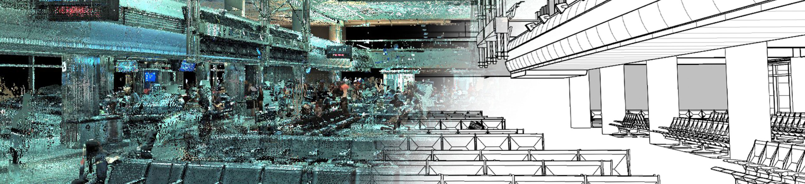
Virtual access to the interior of Moore Hall at Elizabeth City (N.C.) State University allows Woolpert designers to comprehensively renovate and modernize the historic site.
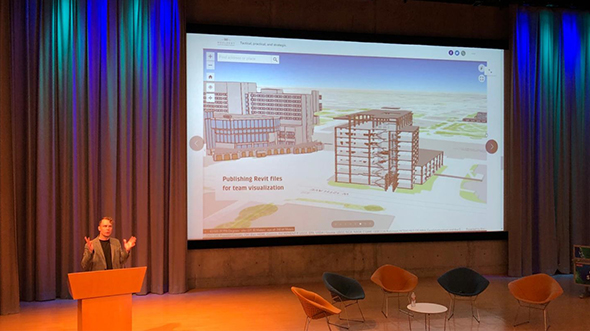
When Woolpert’s Fairview Heights, Ill., office was renovated, reality capture allowed designers at Woolpert offices across the country to review and contribute to the project.
In my first job out of school, I worked with a company that performed many historic renovation projects. I’ll never forget the many hours I spent in the field, verifying existing conditions and making multiple trips back and forth to the site to make sure our design would work. It was a great learning experience, but it also left me asking, “Is there a better way to do this?”
Fortunately, there now is. Reality capture provides accurate existing condition information, which is critical to project success. My colleagues and I at Woolpert, including Architectural Designer Rick Hahn, are avid promoters of this technology. Since Woolpert is an architecture, engineering and geospatial firm, we’ve learned firsthand how advancements in mapping technologies like lidar, a remote-sensing method used to examine the surface of the Earth, and laser scanning have become powerful architecture and design tools for renovating existing buildings.
Over the last five years, we have realized multiple benefits when using these technologies to renovate buildings. The first benefit is the development and utilization of a point cloud. A point cloud is a collection of three-dimensional points, much like taking 360-degree photos with a camera. Point cloud data in or of a space allows for virtual, 360-degree views of that space. These views provide comprehensive access to that space and enable architects and engineers to zoom in and around what was scanned at the project site while they are back at the office.
Prior to having this virtual data, designers would have to rely on pictures taken at the site and often, they would need to see something that was not apparent on the pictures. To get that information, they would either have to revisit the site to take more pictures or take the chance that whatever they were designing would work in conjunction with the existing structure. Costly mistakes could arise if they took that chance, but the time, money and resources required to visit the site again for this purpose also would be costly. With reality capture, the need to choose either of those potentially expensive options is eliminated.
The next great benefit to this technology is that it allows the entire design team to have virtual access to the point cloud model, so they can view whatever area is pertinent to them. Being able to draw dimensions and distances from the model and scan is another phenomenal benefit. With today’s scanners, precision can be fractions of inches. The point cloud takes the guesswork out of the equation and ensures designers are confident in their data.
Technologies like reality capture are increasingly vital to the architecture industry as it continues to advance and expand. The Woolpert Design Technology Management Team was formed to support these proven innovations and propel the industry’s continual development and improvement. The team integrates aerial and mobile lidar, unmanned aircraft system imagery and the application of static scanning to ensure our clients have the best and most cost-effective deliverable, employing the most accurate and appropriate tools.

Andrew Rider
Woolpert Director of Design Technology and blog author Andrew Rider, CM-BIM, is a BIM manager who has more than a decade of experience working in advanced CAD and BIM technologies. The experienced and versatile technician has been with Woolpert for more than eight years.

Rick Hahn
Rick Hahn, AIA, is an architectural designer with more than a decade of experience in project management, business development and design. He has been with Woolpert for nearly a year.
Share this Post