
…lidar, engineering and urban development serves the needs of all hazards and lends a better understanding of our built environment and societal benefits.”Ambrose said he hopes to augment the firm’s…
SportsPlex Celebrates Stadium, Facility and Community Collaboration at Grand Opening

…from tourism to the urban ecosystem to profitability to community impact before plans were made and ground was broken. Based on this information, the SportsPlex at Matthews was constructed to…
Woolpert Opens Office in Historic Over-the-Rhine Neighborhood
…the area, which continues to fuel the growth of Cincinnati’s urban core,” Palazzolo said. “We’re excited to welcome Woolpert to Over-the-Rhine.” Woolpert’s new Cincinnati office is now open for business….
Woolpert Collects Planimetric Data, Processes with Newly Patented AI Mapping System
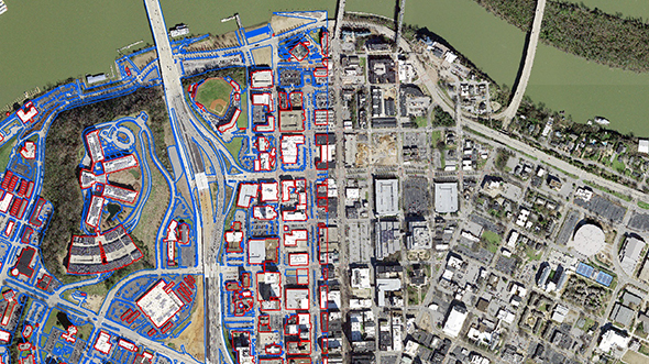
…absorbing into the ground, increasing runoff volume, flood risk and urban water pollution. Impervious surfaces can be linked to a particular parcel within a target geographic area for billing purposes…
Lower Greens Bayou Watershed Planning Study
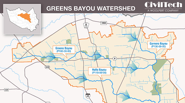
Lower Greens Bayou Watershed Planning Study \n\n Print Friendly Version\n\n Background The Lower Greens Bayou Watershed contains primarily urban environments with a mixture of residential and commercial properties. Challenge The…
Columbus Selects Woolpert to Provide Engineering, Survey for Sidewalks Around Schools
…of the Columbus City Council’s initiative to support and improve the safety and quality of life of city residents by installing sidewalks around schools within three urban neighborhoods. Woolpert has…
54-Inch PCCP Force Main Design-Build Rehabilitation
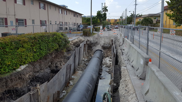
…ran through a very dense urban section of Miami, the team also developed a complete maintenance of traffic plan.\n\n Client Miami-Dade Water and Sewer Department (WASD) Location Miami, FL Services…
Woolpert to Conduct Study for Reconstruction of Sandstone Arch Bridge
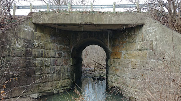
…an urban setting can be challenging,” Denny said. “But, when well-executed, these projects can provide outstanding results.” Denny said he’s looking forward to working with Franklin County Engineer Cornell Robertson,…
Woolpert Staff Shares How They Celebrate Earth Day Every Day

…into our lakes, rivers and waterways. By being highly involved with the International Erosion Control Association, Woolpert has implemented new, resilient and sustainable erosion prevention practices for stabilization of urban…
Transit
Transit\n\n From urban corridors to interstate highways, Woolpert’s work on transportation infrastructure enhances user access and supports growing commerce. Our national, multimodal staff is comprised of planners and engineers experienced…
Birkla Investment Group and Woolpert Partner to Design Multifamily, Mixed-Use Second Phase of Proscenium in Carmel

…summer 2023. About Birkla Investment GroupBirkla Investment Group, founded by Tony Birkla, has more than 30 years of experience in designing and developing urban-styled, residential, multi-family communities. Each custom development…
Architectural Design
Architectural Design\n\n Our firm’s architecture story began quietly. More than 30 years ago, we created an urban waterfront development strategy for a riverside Indiana town. Included in the plan was…
Court Street Renovation
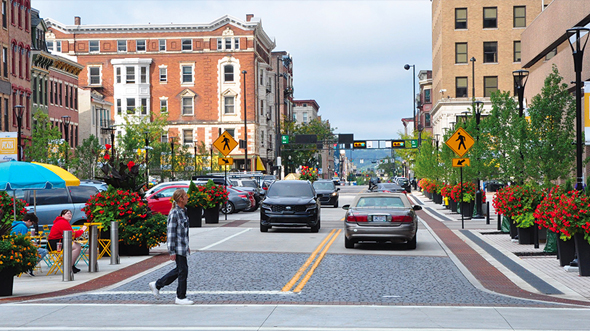
…sidewalk…all the more important.” Cincinnati Mayor John Cranley\n\n Client Cincinnati Center City Development Corporation Location Cincinnati, OH Services Surveying Civil engineering Traffic engineering Landscape architecture Urban design Lighting design \n\n…
Google Earth Engine
…for use. Crop Monitoring and Taxation State and local governments can use aerial and satellite imagery with Google Earth Engine to create baselines of urban and rural land use to…
FDOT Advanced Air Mobility Planning Phase 1

FDOT Advanced Air Mobility Planning Phase 1 \n\n Background FDOT AO initiated this planning project in response to the rapid growth of AAM and urban air mobility. Woolpert was…